Corinth Report: Nezi Field 2007 by J. Matthew Harrington and Theodora Kopestonsky (2007-05-21 to 2007-06-08) | Collection: | | Corinth | | Type: | | Report | | Name: | | Nezi Field 2007 by J. Matthew Harrington and Theodora Kopestonsky (2007-05-21 to 2007-06-08) | | Title: | | Early Roman to Modern periods in the area north of Nezi field | | Context: | | Nezi Field, context 5046 | | | | Nezi Field, context 5038 | | | | Nezi Field, context 5120 | | | | Nezi Field, context 5034 | | | | Nezi Field, context 5033 | | | | Nezi Field, context 5113 | | | | Nezi Field, context 5146 | | | | Nezi Field, context 5134 | | | | Nezi Field, context 5139 | | | | Nezi Field, context 5029 | | | | Nezi Field, context 5080 | | | | Nezi Field, context 5100 | | | | Nezi Field, context 5151 | | | | Nezi Field, context 5155 | | | | Nezi Field, context 5119 | | | | Nezi Field, context 5148 | | | | Nezi Field, context 5135 | | | | Nezi Field, context 5098 | | | | Nezi Field, context 5117 | | | | Nezi Field, context 5153 | | | | Nezi Field, context 5091 | | | | Nezi Field, context 5094 | | | | Nezi Field, context 5064 | | | | Nezi Field, context 5032 | | | | Nezi Field, context 5060 | | | | Nezi Field, context 5044 | | | | Nezi Field, context 5131 | | | | Nezi Field, context 5129 | | | | Nezi Field, context 5127 | | | | Nezi Field, context 5102 | | | | Nezi Field, context 5099 | | | | Nezi Field, context 5088 | | | | Nezi Field, context 5101 | | | | Nezi Field, context 5087 | | | | Nezi Field, context 5121 | | | | Nezi Field, context 5041 | | | | Nezi Field, context 5150 | | | | Nezi Field, context 5085 | | | | Nezi Field, context 5027 | | | | Nezi Field, context 5043 | | | | Nezi Field, context 5103 | | | | Nezi Field, context 5031 | | | | Nezi Field, context 5114 | | | | Nezi Field, context 5116 | | | | Nezi Field, context 5152 | | | | Nezi Field, context 5157 | | | | Nezi Field, context 5132 | | | | Nezi Field, context 5042 | | | | Nezi Field, context 5112 | | | | Nezi Field, context 5154 | | | | Nezi Field, context 5079 | | | | Nezi Field, context 5142 | | | | Nezi Field, context 5128 | | | | Nezi Field, context 5090 | | | | Nezi Field, context 5039 | | | | Nezi Field, context 5028 | | | | Nezi Field, context 5047 | | Area: | | Nezi Field | | Site: | | Corinth | | City: | | Ancient Corinth | | Country: | | Greece | | References: | | Baskets (57)
|
Excavation Summary
During the third training session of the 2007 season, we, J. Matthew Harrington and Theodora Kopestonsky, conducted excavations in the area north of the Nezi field for a total of fourteen days between 21 May 2007 and 8 June 2007. We worked under the supervision of Guy Sanders, James Herbst, Alicia Carter, and Sarah James, with three workmen each day: Panos Kakouros (pickman), Kostas Arboris (shoveller), and Takis ??? (barrowman). Initially, our area of excavation covered approximately 51 square meters, located at 272.8 to 266.2 E and 1014.4 to 1022.6 N. This area is located north of W19 and its robbing trench (NB228), south of the north wall of Room F (NB228), east of the west wall of Room F (NB228), and west of W22 and its foundation trench (NB228). This area is divided along an east-west axis by W38 (NB228), and there were large depressions remaining from the 1961 excavations of Bothros 6 (NB228) and Bothros 7 (NB228). The descriptions of earlier excavations in this area are to be found in notebook 228 and in Nezi north B5001 to B5082. Prior to the second excavation session, cleaning passes were taken over the entire area (B5002, B5003). The global objective of our excavations in this area was to determine the phasing and dating of the walls and features revealed during the 1961 excavations, with a view toward the future unification of this area with the new excavations immediately to the south. We excavated using the open area system as opposed to the trench system in use in the 1961 excavations. This is the first year for the change in excavation systems. On the final day of excavation we moved to an area west of the north-south road (cardo at c. 286E), measuring approximately 14.8 square meters, located at 282.3 to 285.8 E and 1017.5 to 1021.9 N. The following interpretive summary of the stratigraphy revealed to date will describe the strata in chronological sequence, proceeding from Early Roman activity (in the Room north of Room F,W), through Middle Roman strata associated with the demolition and construction of walls (in Room F), through the Late Roman activity connected to occupation, to the Byzantine occupation, and Frankish wall robbing. Although several coins were recovered in the course of the excavations, we are awaiting analysis due to the large number of coins recovered.
Early Roman
Excavations of the fill in the Room north of Room F,W (NB228) west of the crosswall revealed strata (B5088, B5090, B5091) dating to the 1st century AC that appear to be leveling fill for the room. This fill was cut by a sequence of two concentric pits, the earlier (B5085, B5087) and the latter (B5079, B5080) both dating to the 3rd to 4th centuries AC. To the west to fill was cut by the foundation trench (B5060, B5064) of the west wall of Room F (NB228), also dating to the 3rd to 4th centuries AC. To this point, a foundation trench has not been detected along the northern side of W38 (NB228).
Middle Roman (3rd to 4th AC)
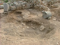
Based on its elevation and configuration, the clay floor surface revealed by B5129 and B5132 is likely to date to the beginning of the Middle Roman period. It is cut by two pits of roughly contemporary date. One is a shallow, oval pit c. 0.75 by 1.0m with a north-south axis (B5134, B5153, B5154, B5155). Remnants comprising the majority of an amphora were excavated with a layer of ash (B5154) that may have been contained within the vessel. This fill will be water sieved. The other pit, roughly oval and measuring c. 0.90 by 1.0m with an east-west axis, was located beside a threshold at the corner of W19 (NB228) and the west wall of Room F (NB228). The fill (B5135) contained large amounts of ash and charcoal, and the finds recovered from the pit also showed evidence of burning: painted wall plaster, fine glassware, a Niederbieber type 77 amphora, and a one-half life size marble bust. The marble bust shows much greater exposure to fire on its right side, indicating that it was exposed to a fire rather than being intentionally burned. The situation of the pit as well as the contents suggest that the deposit was a calculated act intended as a ritual of as yet undetermined significance. It is possible that the contents of the pit represent goods and decoration from an elite house destroyed in part or in total by fire and subsequently ritually buried beside a threshold in a new residence constructed in the same general location but on a different plan.
The floor surface was also cut by the foundation trench (B5157) of the west wall of Room F (NB228). This foundation trench may be relatable to the strata excavated from the foundation trench of the west wall of Room F in the room north of Room F, W (B5060, B5064). As noted above, the Early Roman fill in the room north of Room F, W was cut by a sequence of two concentric pits, the earlier (B5085, B5087) and the latter (B5079, B5080) both dating to the 3rd to 4th centuries AC. It is probably that the use period of the clay floor surface was associated with the crosswall at c. 269E; it may also be that both features went out of use contemporaneously.
Late Roman
A major spatial reorganization of this area occurred in the Late Roman period around the late 4th to early 5th centuries AC. The crosswall at c. 269E (associated with the clay floor surface) was robbed out and backfilled with fill dating to the early 5th century AC (B5142, B5146, B5148, B5150, B5151, B5152). Probably at the same time or nearly so the west wall of Room F (NB228) was constructed at c. 266E. Part of its foundation trench was excavated as B5157 and dated to the 4th century AC; north of W38 (NB228), the west wall of Room F appears to continue northward, and B5060 and B5064 dug in its foundation trench date the wall to the 3rd to 4th century AC. The combination of these dates with the sequence of the clay floor surface and its covering strata suggests that the west wall of Room F (NB228) dates post 4th century AC, likely in the early 5th century AC at the time the floor appears to have gone out of use and the crosswall was removed. At c. 271.5E, a foundation trench was dug for W22 (NB228) and completely filled with strata containing very high percentages of medium cobbles and tile fragments (B5098, B5102, B5103, B5120). After the construction of the two new walls, a leveling fill (B5129, B5131, B5132, B5139) that dated after the 4th century AC was spread over the extent of the area between W22 (NB228) and the west wall of Room F (NB228). This fill postdates the construction of W22 (NB228), since its lowest layer (B5139) overlies part of the foundation fill of the wall and extends all the way to the wall. The situation with the west wall of Room F (NB228) is similar with B5129, in that the fill of B5129 extends to the west wall of Room F (NB228).
Middle Byzantine (10th to 12th AC)
The 1961 excavations removed most strata of the periods after the 6th century AC from the area of our initial excavations with the exception of fill in the bottom of Bothros 7 (NB228 - excavated in B5028, B5029, B5046, and B5047) and to the north and south of Bothros 7 (NB228) along the line of the robbing trench of the crosswall at c. 269E (B5044, B5094, B5128). It is likely that the construction of Bothros 7 (NB118) resulted in an area of mixed late Roman and middle Byzantine fill (north of the pit: B5027, B5031, B5032, B5034, B5039, B5041, B5042, B5043, B5044 - and south of the pit: B5121, B5128) over and partially cut into fill of the middle Byzantine period (B5033, B5038) as well as into the post 4th century AC leveling fill in Room F (B5129, B5131).
The various strata suggest a date of around the 12th century AC for Bothros 7 (NB228). Although the original strata of Bothros 6 (NB228) were removed by the 1961 excavations, the relationship of the pit to W22 (NB228) would place the pit certainly after the 5th century AC and more probably in the Byzantine period to allow a reasonable period of use for W22 (NB228). It is clear that the stones of the upper courses of W22 (NB228) were robbed out between the northern limit of Bothros 6 (NB228) and W19 (NB228), but that the less useful fill of the foundation trench was only removed where it interfered with the need for new construction.
Frankish (mid-13th AC)
A distinct change to a darker, more compact fill (B5113) at the bottom of the robbing trench of W19 (NB228) may indicate that a stratum undisturbed by the 1961 excavations was preserved. This fill dated to the mid 13th century AC.
In the second area of our excavations west of the north-south road (cardo at c. 286E), a sequence of strata oriented along a southwest to northeast axis date to the Frankish period as well. These strata are aligned with a buried conduit connecting the castellum at 284E and 1016N to the well at c. 286.5E and 1022.5N. The removal of these contexts revealed a well-defined fill stretching from the eastern edge of B5162 under the un-cleared erosion accumulation in the ditch c. 286E.
Modern (post 1961)
A sequence of strata (B5116, B5117, B5119, B5127) that dated to the Late Roman period were removed from Bothros 6 (NB228); however, it is our view that these represent eroded accumulation from the strata to the west (B5131, B5139) and east (B5112, B5114) of the pit. It was apparent that Bothros 6 (NB228) was dug beyond its proper cutting on the eastern side, since no cutting on the expected line of the pit was present but rather a loose fill resting over the stones of W20 (NB228). In addition, stones from the wall had fallen into the accumulated strata in the pit. There were a number of levels of eroded accumulation (B5099, B5100, B5101) in the robbing trench of W19 (NB228) that dated to the middle Byzantine and early Modern periods; it is likely that these strata came from the balk immediately to the south left by the 1961 excavations.
Conclusions and Caveats
Excavation in the room north of Room F, W are several centuries and decimeters further than those to the south of W38 (NB228); it will be necessary to excavated the clay floor surface and its associated fill (under B5132) and the strata east of the robbing trench of the crosswall at 269E (under B5139) prior to a return to the strata under B5191. The phasing of W38 (NB228) and the crosswall at 269E is of high importance to the configuration of the space.
It would be useful to continue the excavation of the castellum at 284E and 1016N and its associated conduit by cleaning the area of the ditch at c. 286E and around the castellum and them removing the aligned stratum, which may give a construction date for the hydraulic complex. To date, the majority of the coins associated with our contexts have not been read; it will be necessary to revisit the dating when that evidence becomes available.
|