

| Collection: | Corinth | |
| Type: | Basket | |
| Name: | Nezi Field, context 5686 | |
| Area: | Nezi Field | |
| Context Type: | Fill | |
| Title: | topmost fill for foundation trench of Wall 4 (5724 | |
| Category: | Deposit | |
| Notebook: | 1101 | |
| Context: | 5686 | |
| Page: | 0 | |
| Date: | 2008/05/28 | |
| Lot: | Lot 2008-003 | |
| Stratum: | 20% inclusions: tile, pottery, small angular cobbles, small rounded pebbles, bone, large pottery fragments | |
| Description: | Top slope of the context is steep down to the W. The soil color is light reddish brown. The soil compaction is firm. The soil is poorly sorted. It is sandy silt. | |
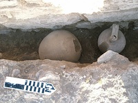
| Notes: | We identified this soft fill as belonging to a foundation trench because it was notably softer than the surrounding soil matrix, and because we thought that it would be probable that since walls 4 and 6 bond, and since the foundation trench of Wall 4 cut the topmost fill covering the plaster floor, then there would probably also be a N-S running foundation trench pairing with Wall 4. This proved to be the case; the soil was notably softer and darker, and continued downward in a line along Wall 4. Approximately 0.40 m into the cut, two whole vessels were lodged into the soil matrix. There was another half of an amphora resting against the edge of the cut about 0.10 m above that. There appears to be a bottom boundary for the cut, and it seems to go in a tapering fashion downward toward the wall. There are two problems that pertain to the limits of the foundation trench. One is that the limit of the foundation trench for Wall 4 appears shallower than the limit of the foundation trench for wall 6. The other problem is that one of the whole pots appears to disappear into the E section of the cut. If this is the case, it means that the top cut would have to end prior to where the pot protrudes, and that there would perhaps be a second foundation trench below. We will discover the nature of this cut when the pit is removed. Update, 29.05.08: We continued excavating the in-situ pots and found that they were embedded inside the matrix of fill inside of the foundation trench, rather than being wedged into one of the walls that the trench itself cuts. This means that the pots may represent part of a deliberate foudation deposit for the N-S running wall 4. About 0.05 m below the level at which the pots rested, the pickman detected a change in texture, which closed off the context. This leaves us with a few unanswered questions abou the walls that we may answer with excavation: 1) If the walls bond at upper and lower levels, and if the foundation trench for Wall 6 was excavated to 84.22, then why is the foundation fill ending at the elevation of 84.51 MASL for Wall 4? The possibilities are thus: A) The walls were founded at similar times, but the foundaton trench of Wall 6 was made to cut and go deeper than that of Wall 4's- perhaps because Wall 6 runs deeper than Wall 4. B) We missed a differentiation of soil when we excavated foundation fill 5680. Further excavation ought to clarify the nature of the foundation trench, since we do not yet see a bottom limit for the stones of Wall 4; however, only excavating to the E of the bothros bordering Wall 6 will tell us whether we missed a differentiation in the foundation trench for Wall 6. | |
| Context Pottery: | Coarseware. amphora. 1 handle. 11 bodysherds. (saved to lot) .; Coarseware. pitcher. 1 handle. 1 bodysherd. (saved to lot) .; Fineware. premedieval10 bodysherds. ; Cooking ware. mug. 2 rims. 1 bodysherd. (saved to lot) .; Coarseware. storage jar. 1 complete profile. (saved to lot) .; Fineware. slipped plain glazed (1100-1300), cup. 1 handle. (saved to lot) .; Fineware. ww plain (700-1120), plate. 1 bodysherd. (saved to lot) . | |
| Pottery Summary: | 7 frag(s) 0.11 kg. (29% saved) fineware. | |
| 35 frag(s) 5 kg. (46% saved) coarseware. | ||
| 174 frag(s) 0.3 kg. (4% saved) cooking ware. | ||
| Context Artifacts: | glass, clear, white bs 1; marble revetment 1; glass, opaque, blue, bs 1; glass, clear, blue bs 1; ceramic waster 1 (saved to lot); iron nail, round shank, 0.05 m L.; iron shank, round; blue stone tessera 1 | |
| Period: | Late Byzantine (1059-1210 AD) | |
| Chronology: | early 12th, 1120 +/- 10 | |
| Grid: | 261.63-261.227E, 1031.75-1034.175N | |
| XMin: | 261.227 | |
| XMax: | 261.63 | |
| YMin: | 1031.75 | |
| YMax: | 1034.175 | |
| Site: | Corinth | |
| City: | Ancient Corinth | |
| Country: | Greece | |
| Masl: | 84.51-84.89m. | |
| References: | Report: Nezi Field 2008 by Sarah Lima (2008-04-07 to 2008-06-13) Image: digital 2008 0160 Image: digital 2008 0163 Image: digital 2008 0164 Object: C 2008 10 Coin: 2008 192 |
|