Corinth Report: Nezi Field 2007 by Lydia Herring, Josh Langseth, Kris Lorenzo (2007-04-09 to 2007-04-27) | Collection: | | Corinth | | Type: | | Report | | Name: | | Nezi Field 2007 by Lydia Herring, Josh Langseth, Kris Lorenzo (2007-04-09 to 2007-04-27) | | Title: | | Pre-Early Modern to Modern Strata in the Southern End of Nezi Field | | Context: | | Nezi Field, context 25 | | | | Nezi Field, context 37 | | | | Nezi Field, context 11 | | | | Nezi Field, context 46 | | | | Nezi Field, context 47 | | | | Nezi Field, context 7 | | | | Nezi Field, context 45 | | | | Nezi Field, context 55 | | | | Nezi Field, context 35 | | | | Nezi Field, context 29 | | | | Nezi Field, context 17 | | | | Nezi Field, context 40 | | | | Nezi Field, context 39 | | | | Nezi Field, context 19 | | | | Nezi Field, context 18 | | | | Nezi Field, context 38 | | | | Nezi Field, context 9 | | | | Nezi Field, context 51 | | | | Nezi Field, context 6 | | | | Nezi Field, context 27 | | | | Nezi Field, context 16 | | | | Nezi Field, context 10 | | | | Nezi Field, context 20 | | | | Nezi Field, context 56 | | | | Nezi Field, context 53 | | | | Nezi Field, context 15 | | | | Nezi Field, context 28 | | | | Nezi Field, context 4 | | | | Nezi Field, context 49 | | | | Nezi Field, context 26 | | | | Nezi Field, context 12 | | | | Nezi Field, context 36 | | | | Nezi Field, context 23 | | | | Nezi Field, context 41 | | | | Nezi Field, context 2 | | | | Nezi Field, context 1 | | | | Nezi Field, context 30 | | | | Nezi Field, context 48 | | | | Nezi Field, context 21 | | | | Nezi Field, context 3 | | | | Nezi Field, context 52 | | | | Nezi Field, context 42 | | | | Nezi Field, context 44 | | | | Nezi Field, context 50 | | | | Nezi Field, context 5 | | | | Nezi Field, context 33 | | | | Nezi Field, context 8 | | | | Nezi Field, context 22 | | | | Nezi Field, context 43 | | | | Nezi Field, context 54 | | | | Nezi Field, context 13 | | | | Nezi Field, context 32 | | | | Nezi Field, context 24 | | | | Nezi Field, context 34 | | | | Nezi Field, context 31 | | | | Nezi Field, context 14 | | Area: | | Nezi Field | | Site: | | Corinth | | City: | | Ancient Corinth | | Country: | | Greece | | References: | | Baskets (56)
|
INTRODUCTION
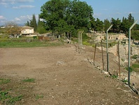
In the past three weeks, we, Lydia Herring, Josh Langseth, and Kris Lorenzo, opened an area at the extreme north of the Nezi field under the supervision of Director of Excavation Guy Sanders and Site Supervisor Alicia Carter. Nezi field is an orchard south of the area excavated by Henry S. Robinson in the 1960s south of the South Stoa in the Forum. We worked with a crew of workmen including Kleomenis Didaskalou (pickman), Billy Papanikolaou (pickman), Andreas Oikonomou (pickman), Vassilis Kollias (shovelman), Iannis Oikonomou (shovelman), Andreas Didaskalou (barrowman), Vangelis Kollias (barrowman), Sotiris Raftopoulos (barrowman), and Thanasis Notis, the foreman. The original area we began to excavate on April 10, 2007 covered ca. 162 square meters located 263 E to 279 E and 1002 N to 1008 N (minimum) / 1013.85 N (maximum). The northern edge of the excavation area is an escarpment left by the excavations of 1936 and 1961, and thus irregular. On Wednesday, April 18, we extended the excavation area to the south in order to find the limit of an orange clay feature at the southern boundary of the excavation area. The addition covers 266 E to 271 E and 1002 N to 1001 N. The current excavation area thus covers ca. 167 square meters.
Our objective is to investigate Turkish, Frankish, and Byzantine remains and connect them to what was excavated in Agora SW section E (NB 227, 228, and 237) and section J (NB 254, 262, 267, 294) in 1961, along with the exploratory trench dug by Amyx and Morgan in 1936 at the southern extreme of the Giambourani field (the field just north of the Nezi field).
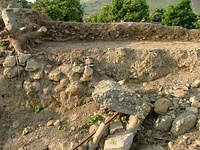
The entire excavation area is divided into two unequal parts by a wall running roughly E-W, which we are continuing to uncover. Within our excavation area, the wall is 16.28 m long, 0.57 m in width, and preserved to a maximum height of 0.55 m above ground. Its maximum northing is 1011.70 N, and the minimum northing is approx. 1009.20 N, where it joins the northern scarp of the excavation area. This wall continues past our excavation area both east and west, but is not preserved to the same height from 275.80 E to beyond the eastern edge of our excavation area, where it has collapsed, thus revealing the north scarp to the eye in this area. It is constructed of field stones arranged in random courses with mud as a bonding agent. This wall was presumably excavated in part by Amyx and Morgan in 1936 (NB 153, 154).
This essay will describe the activity in our area in chronological order based upon our interpretation of the stratigraphy. So far, our read pottery, coins, and small finds provide a date of Early Modern for most of our deposits. This date coincides well with our interpretation of formation of the excavation area.
PRE-EARLY MODERN
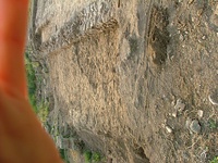
The earliest activities in our excavation area are represented by an area of destruction debris consisting of densely-packed roof tile fragments lying horizontally on a clay surface (B51=B58=B59). These tiles extend from 267.60 E to 271 E, and 1006.90 N to the southern edge of the excavation area, and may extend beyond it. The tile scatter also contained worked marble fragments. The tiles are scattered in a concentrated area, with their north and east extents noticeably rectilinear. This deposit is dated by pottery to the Frankish period, ca. 1260-1280 CE. South of this tile scatter is an orange clay feature (as yet unexcavated) surrounded on its north and northeast sides by stone blocks, on the very edge of which some of the tiles rest. This feature (1004 N to 1001.53 N and 268.95 E to 267 E) contains orange clay, white clay, and gray clay.
Based upon the presence of a tile scatter, fragments of worked stone, clay of three different colors, and worked blocks bordering the aforementioned clay, we have formulated three hypotheses: that the extant evidence indicates the destroyed remains of some sort of enclosure associated with 1) a hearth, 2) a potting installation, or 3) a floor(s).
This area of destruction debris is cut by a large pit or well (B36, B37, B39, B41, B43, B46; 1008.08 N to 1005.96, and 268.40 E to 266.40 E). Five of the six lenses of fill of this pit or well are dated by pottery to the second Ottoman period (AD 1715 -1831) and may represent a filling in of this feature at that time. IT is possible that this activity may be related to the large and well-built Ottoman house (the Giambourani House) previously excavated less that 10m to the NW of Nezi field. The uppermost lens of fill (B36) in this pit or well contained Early Modern pottery and we suggest that this deposit may have been dumped into the pit in the Early Modern period to level out the surface of the ground in this area of the field as the settling of earlier dumped fills may have created a depression in the ground over time. We have temporarily ceased excavating this pit because it is 1.41 m deep and difficult for the workmen to climb in and out of; excavation will resume once the surrounding deposits have been excavated to a more manageable depth.
North of this area of destruction a robbing trench (B52/B54) has been excavated at 1011.5 – 1014N/264 – 264.85E. This robbing trench was dug to partially rob a N-S running wall that continues into the previously excavated area to the north of Nezi field, thus linking the two areas. Pottery from the fill of the robbing trench dates to the Frankish period, ca. AD 1300. But further excavation is needed to establish a more reliable date based on the relations between the robbing trench and other deposits and features in the area. Specifically, we want to know the relationship between the robbing trench and the E-W wall that may (or may not) cut it at ca. 1011.5N/264.5E. We also want to excavate more of the deposits cut by the robbing trench to establish a more secure date.
EARLY MODERN
The Early Modern activity in the excavation area is agricultural in nature, consisting primarily of two phases of plowing and planting in the southern half of the excavation area. The earlier phase was excavated with B23=B27=B30=B33=B34=B50=B57=B62 which overlay the entire excavation area. The mixed nature of this soil and its lack of association with any built structures suggest to us that this is plow zone. Several deposits excavated immediately under this zone also contained Early Modern pottery (B14, B36, B38, B44, B57=B61). Based on their location at the northern down-slope end of the field and their relative depths, we suggest that these deposits were purposefully laid down to level the field for the planting of crops in this first phase of Early Modern agricultural activity.
The later phase of plowing was excavated with B2=B24, which overlay distinct plow furrows (the cuts of which were recorded with B22). The furrows vary in length and width and run from the eastern extreme of the excavation area to the western extreme. They first appear approximately one meter south of the E-W wall.
Associated with later phase of Early Modern agricultural activities is a linear pile of stones excavated with B4 (1009.70 N to 1010.90 N, and 264.70 to 272.66 E in its extremes). This layer abuts the south face of the E-W wall and we suggest that it is a pile of field cobbles which farmers cleared from the field in the course of their agricultural activity to the south. Since these cobbles predate the later phases of fencing (see below for B16, B17) between Nezi field and Giambourani field, we hypothesize that there was an earlier fence or field boundary, which B17 replaced, but has left no discernable trace.
Also associated with the later phase of Early Modern activity in Nezi field is a small pit (fill of this pit = B44) of dumped material including ash, sherds, cobbles and boulders.
MODERN
South of the E-W wall, a series of tree pits and irrigation trenches were cut into the second phase of Early Modern plow zone. The irrigation trenches (B18 = B32, B19) comprise two linear cuts running north-south up to the south-west side of individual tree pits but not joining a specific tree pit (B18 ran up to B7/B10, B19 ran up to B11/B15). Each trench contained a black plastic irrigation hose. The irrigation trenches continue south out of the excavation area, and probably are connected with other tree pits within the existing orange orchard south of the excavation area.
The five tree pits in the excavation area are arranged in three north-south rows, ca. five meters apart. Each of the tree pits (B6/B9, B7/B10, B8/B12, B11/B15, B21/B25) contained an orange tree and root system, all of which the workmen cleared; the workmen, most of whom have extensive agricultural experience, estimate the age of the trees to be no more than forty years old. Each pit cuts the surface cut by plow furrows (furrows = B22) and the soil which the furrows cut (B23=B27=B30=B33=B34=B50).
Tree pit B6/B9 contained very dark black specially fertilized soil with small white polystyrene inclusions and small areas of yellowish white clay. Both the specially fertilized soil and yellowish white clay would have been part of a mix of soil and other matter that surrounded the orange sapling when it was put in the pit. The clay and the polystyrene most likely functioned to retain moisture for the sapling.
Along both sides of the E-W wall are several fill deposits. The uppermost on the north side of the wall (B3) contains worked marble fragments that may be the result of dumping from the 1936 excavation, or also (in this case) the later 1960’s excavations under H. Robinson in sections E and J (see NB228), north of the Nezi field. South of the E-W wall are two fill deposits (B5, B14) that may perhaps be the result of terracing for agricultural activity. However, the uppermost fill (B5) also included marble fragments, some of which were worked. Because similar fragments also occur in the fill north of the E-W wall (B3)—which, along with B5, also directly borders Amyx and Morgan’s 1936 excavation trench in what was later called section E by Schmiel in 1961 (NB228)—we hypothesize that this fill is most likely fill dumped by the 1936 excavators. Worked marble fragments have been found only in these two contexts in the area along the north scarp.
These fill deposits are cut by the latest activity in our excavation area: the construction of two phases of cement foundations used to anchor a series of posts supporting chain-link fencing. This fencing runs along the northern boundary of Nezi field. Both phases of fence foundations were partly cemented onto the E-W wall at ca. 1011.70 N and destroyed this wall in these places.
The earlier phase of fencing survives as a series of small, whitish gray cement foundations (B17). The second phase of fencing survives as a series of noticeably larger concrete slabs spaced at regular intervals (B16). We know this phase is later because the metal posts were still intact as a functional fence at the beginning of excavation. It is possible that these two phases of fencing were built at the times of the two previous excavation campaigns in this area of the archaeological site, one in 1936 and one in 1961.
CONCLUSION
The first three weeks of excavation in Nezi field have produced a stratigraphic sequence and grouping of associated finds to indicate a solidly Modern and Early Modern date for the vast majority of our excavated contexts. The possibly earlier contexts consist of the pit (B36, B37, B39, B41, B43, B46), the tile scatter, and the orange-clay feature. We hope that further excavation will refine our chronology. We will continue our notebook research on the previously excavated area north of Nezi field in order to understand better the relationship between that area and the stratigraphy of Nezi field, particularly in the area north of the E-W wall. Based on the remains of an enclosure in the SW corner of the excavation area and the robbing trench with its associated wall projecting out of the north scarp, we are hopeful of fulfilling our goal of investigating Turkish, Frankish, and Byzantine remains and connecting them to previously excavated sections E and J.
|